Sunday Nor’easter?
Sunday Nor’easter?
![]() by b632 » Tue Jan 02, 2024 7:25 am
by b632 » Tue Jan 02, 2024 7:25 am
- b632
- Sugarloafer
- Posts: 2980
- Joined: Mon Nov 13, 2006 2:37 pm
- Location: Portland Me
Re: Sunday Nor’easter?
![]() by Mr. Vesper » Tue Jan 02, 2024 9:37 am
by Mr. Vesper » Tue Jan 02, 2024 9:37 am
The JD Man has Returned
-

Mr. Vesper - Sugarloafer
- Posts: 1706
- Joined: Tue Nov 14, 2006 12:35 pm
- Location: Eagle's Wings Lane
Re: Sunday Nor’easter?
![]() by shot ski » Tue Jan 02, 2024 11:37 am
by shot ski » Tue Jan 02, 2024 11:37 am
- shot ski
- Sugarloafer
- Posts: 367
- Joined: Wed Feb 06, 2013 9:02 pm
Re: Sunday Nor’easter?
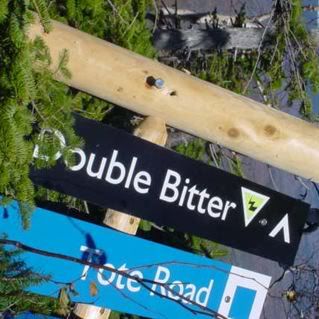
![]() by DoubleBitter » Tue Jan 02, 2024 12:04 pm
by DoubleBitter » Tue Jan 02, 2024 12:04 pm
-
DoubleBitter - Sugarloafer
- Posts: 1033
- Joined: Mon Aug 25, 2008 8:52 pm
- Location: Massachusetts and Maine
Re: Sunday Nor’easter?
![]() by WrathOfAramark » Tue Jan 02, 2024 3:55 pm
by WrathOfAramark » Tue Jan 02, 2024 3:55 pm
Models are hinting at something later on the 10th that might be more potent for northern New England, but we gotta get closer and past this weekend first for it to clear up.
- WrathOfAramark
- Sugarloafer
- Posts: 1548
- Joined: Mon Nov 13, 2006 11:41 am
- Location: If I said I was born and raised 1 mile from the NH border, would you still think me a Masshole?
Re: Sunday Nor’easter?
![]() by Andrew B. » Tue Jan 02, 2024 8:43 pm
by Andrew B. » Tue Jan 02, 2024 8:43 pm
WrathOfAramark wrote:Models are hinting at something later on the 10th that might be more potent for northern New England, but we gotta get closer and past this weekend first for it to clear up.
This….. hopefully
And come on up to the Mothership
- Andrew B.
- King Masshole
- Posts: 2939
- Joined: Fri Apr 20, 2007 9:58 am
Re: Sunday Nor’easter?
![]() by b632 » Wed Jan 03, 2024 8:08 pm
by b632 » Wed Jan 03, 2024 8:08 pm
bigelow wrote:stock up on the ptex
Ski em like you stole em
- b632
- Sugarloafer
- Posts: 2980
- Joined: Mon Nov 13, 2006 2:37 pm
- Location: Portland Me
Re: Sunday Nor’easter?
![]() by b632 » Wed Jan 03, 2024 8:10 pm
by b632 » Wed Jan 03, 2024 8:10 pm
- b632
- Sugarloafer
- Posts: 2980
- Joined: Mon Nov 13, 2006 2:37 pm
- Location: Portland Me
Re: Sunday Nor’easter?
![]() by SpillwayEast » Thu Jan 04, 2024 9:29 am
by SpillwayEast » Thu Jan 04, 2024 9:29 am
- SpillwayEast
- Sugarloafer
- Posts: 744
- Joined: Wed Nov 26, 2014 12:18 pm
Re: Sunday Nor’easter?
![]() by WrathOfAramark » Mon Jan 08, 2024 11:01 am
by WrathOfAramark » Mon Jan 08, 2024 11:01 am
Andrew B. wrote:WrathOfAramark wrote:Models are hinting at something later on the 10th that might be more potent for northern New England, but we gotta get closer and past this weekend first for it to clear up.
This….. hopefully
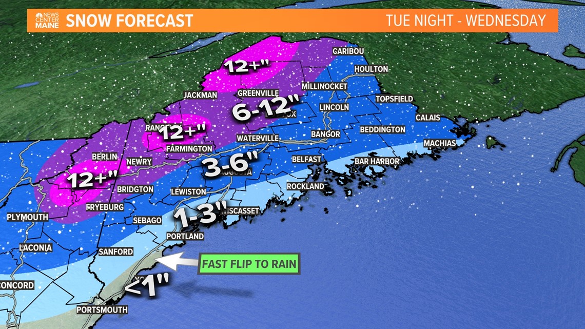
Trending to stay cold in the mountains with cold air being trapped up against the mountains. SL and SB should stay mostly snow with 12"-18" being the current NWS forecast. SR might get less snow and more rain, although it looks like any elevation will be your friend. More concerned about high winds again and power outages, again. If you need gas for your generator, might be good to get it now.
- WrathOfAramark
- Sugarloafer
- Posts: 1548
- Joined: Mon Nov 13, 2006 11:41 am
- Location: If I said I was born and raised 1 mile from the NH border, would you still think me a Masshole?
Re: Sunday Nor’easter?
![]() by shot ski » Mon Jan 08, 2024 3:08 pm
by shot ski » Mon Jan 08, 2024 3:08 pm
- shot ski
- Sugarloafer
- Posts: 367
- Joined: Wed Feb 06, 2013 9:02 pm
Re: Sunday Nor’easter?
![]() by cat in january » Mon Jan 08, 2024 5:57 pm
by cat in january » Mon Jan 08, 2024 5:57 pm
WrathOfAramark wrote:Andrew B. wrote:WrathOfAramark wrote:Models are hinting at something later on the 10th that might be more potent for northern New England, but we gotta get closer and past this weekend first for it to clear up.
This….. hopefully
Trending to stay cold in the mountains with cold air being trapped up against the mountains. SL and SB should stay mostly snow with 12"-18" being the current NWS forecast. SR might get less snow and more rain, although it looks like any elevation will be your friend. More concerned about high winds again and power outages, again. If you need gas for your generator, might be good to get it now.
Looks like it could be in that range by Wednesday morning, but a switch to rain around 9 or 10. Net positive but just as base material. Wind on loaded trees could be bad.
- cat in january
- Sugarloafer
- Posts: 63
- Joined: Thu Nov 03, 2016 8:33 am
Re: Sunday Nor’easter?
![]() by shot ski » Tue Jan 09, 2024 11:53 am
by shot ski » Tue Jan 09, 2024 11:53 am
shot ski wrote:Wednesday and Saturday big potential, another one in the pipeline for early next week. Pattern is definitely busy, just need to bring the pieces together right now they are a bit west of where sugarloaf and the northeast like em.
Most models showing 2-3' by sunday morning between the next two storms.
- shot ski
- Sugarloafer
- Posts: 367
- Joined: Wed Feb 06, 2013 9:02 pm
Re: Sunday Nor’easter?
![]() by Alpiner » Tue Jan 09, 2024 2:47 pm
by Alpiner » Tue Jan 09, 2024 2:47 pm
Glade Monkey wrote:Bullseye!
Followed by almost 2" of rain.
https://www.instagram.com/p/C12jgBwxmIW/?img_index=3
-

Alpiner - Sugarloafer
- Posts: 2204
- Joined: Fri Dec 06, 2013 3:50 pm
- Location: Maine
Re: Sunday Nor’easter?
![]() by cat in january » Tue Jan 09, 2024 3:33 pm
by cat in january » Tue Jan 09, 2024 3:33 pm
- cat in january
- Sugarloafer
- Posts: 63
- Joined: Thu Nov 03, 2016 8:33 am
Re: Sunday Nor’easter?
![]() by Glade Monkey » Tue Jan 09, 2024 3:48 pm
by Glade Monkey » Tue Jan 09, 2024 3:48 pm
Alpiner wrote:Glade Monkey wrote:Bullseye!
Followed by almost 2" of rain.
https://www.instagram.com/p/C12jgBwxmIW/?img_index=3
Hope not but he did write..."The storm will stay mainly snow in the mountains..."
Still, it is never a good thing when Jim Cantore is prowling around and getting excited about coming up to Maine for live shot!
-

Glade Monkey - Sugarloafer
- Posts: 3166
- Joined: Mon Nov 29, 2010 4:36 pm
- Location: Freeport
Re: Sunday Nor’easter?
![]() by myell » Tue Jan 09, 2024 5:06 pm
by myell » Tue Jan 09, 2024 5:06 pm
- myell
- Sugarloafer
- Posts: 218
- Joined: Thu Oct 04, 2007 8:34 am
Re: Sunday Nor’easter?
![]() by shot ski » Tue Jan 09, 2024 5:21 pm
by shot ski » Tue Jan 09, 2024 5:21 pm
Alpiner wrote:Glade Monkey wrote:Bullseye!
Followed by almost 2" of rain.
https://www.instagram.com/p/C12jgBwxmIW/?img_index=3
I think Keiths map is showing total preip, it doesn't differentiate the difference between rain and snow. It looks like sugarloaf stays above freeezing till sunrise tomorrow, maybe 7-8am. By then 1.6" of water (10-16" of snow ) should have fallen. There is maybe a half inch of water left on the backside as rain. Either way it will be a beautiful bullet proof wind blown base ready for the next storm.
- shot ski
- Sugarloafer
- Posts: 367
- Joined: Wed Feb 06, 2013 9:02 pm
Re: Sunday Nor’easter?
![]() by cat in january » Tue Jan 09, 2024 5:24 pm
by cat in january » Tue Jan 09, 2024 5:24 pm
9am. 3,700
10. 4,600
11. 4,300
12. 4,000
1. 3,300
2. 2,800
- cat in january
- Sugarloafer
- Posts: 63
- Joined: Thu Nov 03, 2016 8:33 am
Re: Sunday Nor’easter?
![]() by myell » Tue Jan 09, 2024 6:27 pm
by myell » Tue Jan 09, 2024 6:27 pm
- myell
- Sugarloafer
- Posts: 218
- Joined: Thu Oct 04, 2007 8:34 am
Re: Sunday Nor’easter?
![]() by gondicar » Tue Jan 09, 2024 8:40 pm
by gondicar » Tue Jan 09, 2024 8:40 pm
-

gondicar - Sugarloafer
- Posts: 4258
- Joined: Tue Aug 26, 2008 9:11 am
Re: Sunday Nor’easter?
![]() by BubbleCuffer97 » Wed Jan 10, 2024 8:27 am
by BubbleCuffer97 » Wed Jan 10, 2024 8:27 am
- BubbleCuffer97
- Sugarloafer
- Posts: 116
- Joined: Thu Nov 08, 2018 12:49 pm
- Location: Boston/The Rack
Re: Sunday Nor’easter?
![]() by Glade Monkey » Wed Jan 10, 2024 9:28 am
by Glade Monkey » Wed Jan 10, 2024 9:28 am
BubbleCuffer97 wrote:14" and still dumping. Let's go!
Could be the first Skidway only day of the season
**UPDATE 8:10AM: All lifts with the exception of Skidway will start the day on wind hold. We're starting to see a changeover from snow to sleet as we start the day.
-
Glade Monkey - Sugarloafer
- Posts: 3166
- Joined: Mon Nov 29, 2010 4:36 pm
- Location: Freeport
Re: Sunday Nor’easter?
![]() by SpillwayEast » Wed Jan 10, 2024 9:50 am
by SpillwayEast » Wed Jan 10, 2024 9:50 am
- SpillwayEast
- Sugarloafer
- Posts: 744
- Joined: Wed Nov 26, 2014 12:18 pm
Re: Sunday Nor’easter?
![]() by SkitheLoaf » Wed Jan 10, 2024 10:11 am
by SkitheLoaf » Wed Jan 10, 2024 10:11 am
SpillwayEast wrote:You can text 'Weather' to 603.356.2137 and it will reply with the current temp and wind at the top of Mt Washington..........pretty cool.
Cool! Thanks for sharing!
-

SkitheLoaf - Sugarloafer
- Posts: 401
- Joined: Mon Aug 25, 2008 9:37 pm
Re: Sunday Nor’easter?
![]() by waldo » Wed Jan 10, 2024 10:25 am
by waldo » Wed Jan 10, 2024 10:25 am
- waldo
- Sugarloafer
- Posts: 180
- Joined: Tue Aug 26, 2008 10:17 am
Re: Sunday Nor’easter?
![]() by myell » Wed Jan 10, 2024 11:17 am
by myell » Wed Jan 10, 2024 11:17 am
- myell
- Sugarloafer
- Posts: 218
- Joined: Thu Oct 04, 2007 8:34 am
Return to Snow Conditions, Weather, etc.
Who is online
Users browsing this forum: No registered users and 21 guests